Are historic highways for more than just travel?
Before automobiles began to make a significant impact on Iowa roads around 1910, railroads were the way that people traveled from one town to another. Horse-drawn buggies and wagons moved residents from farm to town and for local travel. Cars, however, enabled Iowans to travel long distances to locations away from train depots and on their own schedule. They brought a new burst of freedom, and Iowans, especially farm families, were among the first to take advantage of the opportunity.
When most travel was local, maintenance of the roads was a local issue. Farmers graded and hauled gravel in their own neighborhoods while the county built bridges along main-traveled routes. When the demand for town-to-town travel and beyond increased with the advent of cars, drivers demanded better roads than the former system could supply. Responsibility for highways connecting major cities fell to the state and eventually even to the federal government. Two of the earliest and most famous highways crossed in central Iowa, providing Iowa drivers access to both coasts and the Gulf of Mexico.
Lincoln and Jefferson Highways
The Lincoln Highway was the creation of private association that mapped a transcontinental route from New York City to San Francisco. State organizations along the way picked out their own routes as cities competed to be on this major thoroughfare. In Iowa, it ran from Clinton on the Mississippi River to Council Bluffs. Local authorities assumed responsibility for maintaining the roadway and sometimes even paving it. Shortly after the end of World War I, Dwight D. Eisenhower was a young veteran officer with an army tour displaying tanks and other armaments to promote the Lincoln Highway. Military officials cited the need for routes that could quickly transport troops in case of another conflict. Towns along the route fed and hosted the traveling troops and vigorously promoted the effort. Greene County became the first in Iowa to pave the Lincoln Highway from border to border.
In 1915, the multi-state Jefferson Highway Association was created, modeled on the experience of the Lincoln Highway. Organizers of this north-south route designated Winnipeg, Manitoba, as the northern terminus and New Orleans as its southern stopping point. The highway entered Iowa at Northwood along the Minnesota border and exited at Lamoni just above the Missouri line. All along the way, communities, businesses, car clubs and other driving enthusiasts cooperated to maintain, mark and promote the route as a major American thoroughfare.
With the absence of detailed maps or a common system of signage, promoters along the way designated the route by painting markers on telephone poles and fence posts along the way. On the Lincoln Highway, there were occasional statues of Lincoln, as well as metal symbols. The Jefferson Highway adopted a red-white-and-blue logo of a big "JH" painted at frequent intervals.
Boost to Local Economy
Location on a national highway boosted the economies and visibility of towns along the route. Filling stations, cafes, motels and camp sites, and tourist attractions sprang up to service travelers. The highways usually ran through the middle of the town to the delight of hometown merchants. However, due to increase traffic, long-haul trucks, and safety concerns, the Iowa Highway Commission in the 1950s began plans to by-pass the Lincoln Highway around towns to speed travel. The towns resisted strongly, but the routes were changed. With the increased traffic and need for ever-wider roadways, the federal and state government took over road maintenance and adopted a numbering system to synchronize markers from state to state. The Lincoln Highway became U.S. Highway 30. The Jefferson Highway was originally Iowa Highway 1 but later designated as U.S. Highway 65.
Local historical groups have recognized the significance of these early highways and the romance of the automobile. They have formed highway associations to restore the original markers (not replacing modern signage) and preserving some of the buildings that once served early drivers. Some gas stations are now museums, and local motel cabins attract visitors trying to reconnect with the excitement of cross-country travel.
Supporting Questions
How have highways like the Lincoln Highway (Highway 30), Jefferson Highway (Highway 65 and 69) and Interstate 80 contributed to Iowa's rich history?
- Excerpts from “A Picture of Progress on the Lincoln Way,” 1920 (Document)
- Iowa Road Map with the Original Route of the Lincoln Highway, 1994 (Map)
- Excerpts from "The Lincoln Highway," 1995 (Document)
- "Brief History of the Lincoln Highway," 2019 (Document)
- History of the Jefferson Highway from Iowa DOT, Date Unknown (Document)
In what ways have Iowa's highways impacted Iowa socially and economically?
- "The Perfect Spot: Iowa 80's Journey from Iowa Cornfield to the World's Biggest Truckstop," 2004 (Document)
- Youngville Cafe on Lincoln Highway Added to National Register of Historic Places, 2007 (Document)
- "Iowa All Over: Preston's Station in Belle Plaine still a draw for passing drivers," June 21, 2015 (Document)
How have people tried to preserve the rich history of Iowa's historic highways?
- Application to Register Jefferson Highway's Route, May 6, 1916 (Document)
- "The Complete Official Road Guide of the Lincoln Highway - Fifth Edition," 1993 (Document)
- Excerpts from "The Lincoln Highway Iowa Map Pack: A Great Iowa Tour," 1994 (Document, Map)
- "Lincoln Highway Heritage Byway - Iowa," November 26, 2014 (Video)
| History of Iowa's Highways Teaching Guide |
| Printable Image and Document Guide |
Excerpt from “A Picture of Progress on the Lincoln Way,” 1920
Description
This text was created by the Lincoln Highway Association, and it outlines the progress in creating the Lincoln Highway. The section on Iowa details the plans for paving the highway and how this debate impacted political and economic interests in the state.
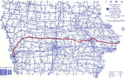
Iowa Road Map with the Original Route of the Lincoln Highway, 1994
Description
This is an Iowa road map from 1994, and it shows the original route of the Lincoln Highway in red.
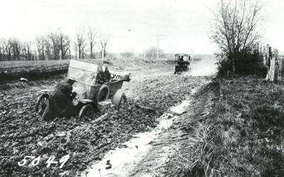
Excerpts from "The Lincoln Highway," 1995
Description
The excerpts selected from this book, "The Lincoln Highway," focus on Alice Ramsey's journey across America. The document chronicles some of her travels along the Lincoln Highway.
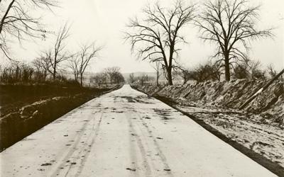
"Brief History of the Lincoln Highway," 2019
Description
This document is a page from the Iowa Lincoln Highway Association website. The material details a brief history of the creation and development of the Lincoln Highway.
History of the Jefferson Highway from Iowa DOT, Date Unknown
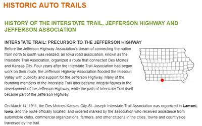
Description
A document is a webpage from the Iowa Department of Transportation. It describes the creation and development of the Jefferson Highway.
"The Perfect Spot: Iowa 80's Journey from Iowa Cornfield to the World's Biggest Truckstop," 2004
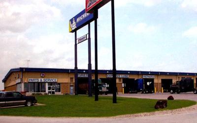
Description
This book provides a brief history on the Iowa 80 Truckstop, which is the largest truck stop along Interstate 80. The selected text focuses mainly on the social and economic impact of the stop.
Youngville Cafe on Lincoln Highway Added to National Register of Historic Places, 2007
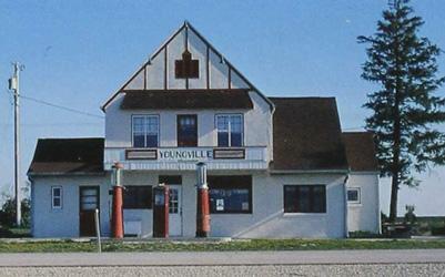
Description
The Youngville Cafe was a one-stop roadside business on the Lincoln Highway. It was in operation from the 1930's to 1967. After going through restoration, it is now part of the National Register of Historic Places.
"Iowa All Over: Preston's Station in Belle Plaine still a draw for passing drivers," June 21, 2015
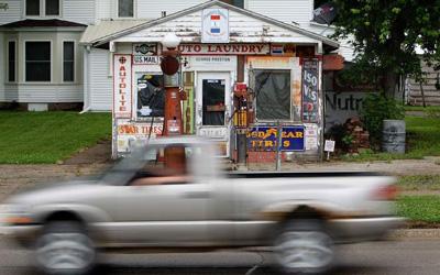
Description
This is an article from The Cedar Rapids Gazette about Preston's Gas Station in Belle Plaine, Iowa. Preston's started operations during the peak years of the Lincoln Highway. Since closing, it has became world famous for its uniqueness and history. The article…
Application to Register Jefferson Highway's Route, May 6, 1916
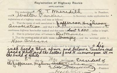
Description
This is the application for registration of highway routes for the Jefferson Highway submitted May 6, 1916.
"The Complete Official Road Guide of the Lincoln Highway - Fifth Edition," 1993
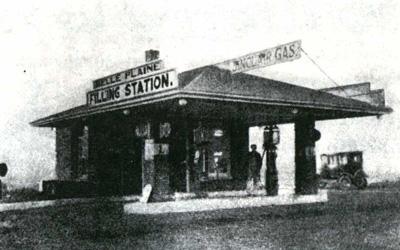
Description
This is an official road guide that describes various points along the Lincoln Highway, and includes several advertisements for specific stops along the highway. This was used to describe the route through Iowa.
Excerpts from “The Lincoln Highway Iowa Map Pack: A Great Iowa Tour," 1994
Description
This is an excerpt from a document that included the original mapped route of the Lincoln Highway. It also includes information about the different significant stops, photos and advertisements from the early years of the highway.
"Lincoln Highway Heritage Byway - Iowa," November 26, 2014
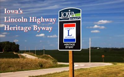
Description
This video was produced by Prairie Rivers of Iowa, and it focuses on the history of the Lincoln Highway/Byway. The video highlights facts about the highway from it creation to today, and it also features photos from throughout the years to show the rich history of the…
Additional Resources:
- Official Map of the Lincoln Highway
This website is an interactive map of the Lincoln Highway. The user can track different generations of the route that travels from New York City to San Francisco. - Iowa Lincoln Highway Association: Counties
This website contains material and research from the Iowa Lincoln Highway Association. The user can search by county to pull information about the route and influence of the Lincoln Highway on that particular Iowa county. - "Ike's Interstates at 50: Anniversary of the Highway System Recalls Eisenhower's Role as Catalyst"
This article written by David A. Pfeiffer was featured in Prologue Magazine and looks at the influence President Dwight D. Eisenhower had on the development of interstate travel in the United States. - Reed/Niland "One-Stop" Corner in Colo, Iowa
This website is dedicated to the history and restoration of the Reed/Niland corner stop that was at the intersection of the Jefferson and Lincoln highways. The stop is located in Colo, Iowa, just East of Ames, and still includes Niland's Café and Colo Motel.
Iowa Core Social Studies Standards (6th-12th Grade)
Listed below are the Iowa Core Social Studies content anchor standards that are best reflected in this source set. The content standards applied to this set are middle and high school-age level and encompass the key disciplines that make up social studies for 6th through 12th-grade students.
| No. | Standard Description |
| SS.6.16. | Utilize and construct geographic representations to explain and analyze regional, environmental, and cultural characteristics. |
| SS.6.18. | Explain how changes in transportation, communication and technology influence the movement of people, goods, and ideas in various countries |
| SS.8.18. | Explain how the physical and human characteristics of places and regions influence culture |
| SS.8.25. | Examine the evolution of the function and structure of government in Iowa. |
| SS-Geo.9-12.18. | Evaluate the impact of human settlement activities on the environmental and cultural characteristics of specific places and regions. |
| SS-Geo.9-12.19. | Analyze the reciprocal relationship between historical events and the spatial diffusion of ideas, technologies, cultural practices and the distribution of human population. |