How does Iowa compare to other places on Earth?
Factors in descriptions reflect the information that one wishes to know. There are many ways that Iowa's location can be identified: latitude and longitude, relationship to neighboring states (south of Minnesota) or height above sea level. Each can be correct. This primary source set focuses on five themes of geography: location, place, human-environment interaction, movement and region.
Landscape and Agriculture
Iowa's landscape is often described in terms of the types of agriculture that each area fosters. The hilly northeast is more suitable to dairy and beef cattle. North Central Iowa has some of the richest farm land in the world spread across relatively flat and well-drained prairies. Western Iowa receives less rainfall than other parts of the states as it starts a transition into the more arid Great Plains. Southwestern and South Central Iowa have hilly pastures like the northeast and support many cattle operations. Southeastern Iowa was originally the most heavily forested region at the time of initial European settlement, especially along the major river valleys that drained the rest of the state.
The Iowa landscape owes much to the series of Ice Ages that brought glaciers scraping down from the northeast. It is generally acknowledged that the far northeastern corner of the state had only minimal glaciation, leaving the rugged hills intact. In the last Ice Age ending some 14,000 years ago, the unstable climate produced glacier fronts that advanced and retreated across hundreds of miles, breaking up the rock into gravel and fine silt that became incredibly rich topsoil over the next two millenia. Agriculture has also vastly changed the Iowa landscape. Almost all of the forests that once covered 15 percent of the state and the prairie cultures that greeted pioneers have been cut down to produce fields for crops and livestock.
Regional Divides
In the early days of European settlement, rivers were the major routes of transportation for both people and goods. Railroads appeared in the 1850s and opened vast tracts of the Midwest to rapid settlement and agriculture commerce. Cars and trucks transformed rural and urban life in the early 20th century followed by commercial air travel starting in the 1930s. The interstate highway system linked the nation more closely than ever in the 1950s.
A regional definition of Iowa also depends on what one considers to be the most significant factors. In agriculture, we are the heart of the Corn Belt that extends from eastern Nebraska through western Ohio. Our Mississippi river towns are similar to the industrial centers of the Great Lakes states. Politically, our loyalty to the Union in the Civil War led to the domination of the Republican Party for over a century and distinguished us from our Democratic neighbor to the south.
Who we are, where we are, what we are ... these are all questions that reflect the principal interest of those asking the questions.
Supporting Questions
Location: How can Iowa’s location be described?
- Galbraith Railway Mail Service Map of Iowa, 1897 (Map)
- Dissected Map of the United States, 1900 (Map)
- Standard Map of the World, 1942 (Map)
Place: How does Iowa’s geography compare to other areas of the world?
- Merchants of the Sahara Desert in North Africa, between 1880 and 1923 (Image)
- Workers Cutting Bananas from Trees in Costa Rica, between 1910 and 1920 (Image)
- Farm Land in Monona, Iowa, May 1940 (Image)
Human-Environment Interaction: How has Iowa’s environment been changed?
- Gowers' Land Agency, 1855 (Document)
- "Beautiful Prairies of Early Iowa" Newspaper Article, August 30, 1911 (Document)
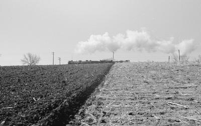
- Freshly Plowed Land in Greene County, Iowa, April 1940 (Image)
Movement: How do people and goods move throughout Iowa?
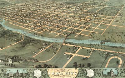
- Bird's-Eye View of Iowa City in Johnson County, Iowa, 1868 (Image)
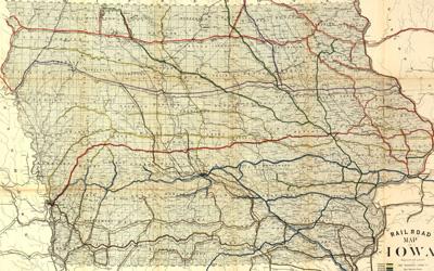
- Railroad Map of Iowa, 1881 (Map)
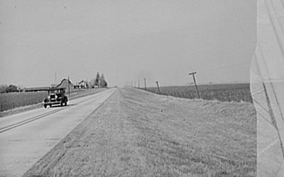
- Highway next to Farm Land in Grundy County, Iowa, April 1940 (Image)
Region: What makes Iowa’s region unique?
- Railroad Map of the American Midwest, 1858 (Map)
- "National Parks of the Midwest," 1968 (Map)
- "Opening of the Midwest" Mural in Cedar Rapids, Iowa, 2011 (Image)
| Five Themes of Geography Teaching Guide |
| Printable Image and Document Guide |
Galbraith Railway Mail Service Map of Iowa, 1897
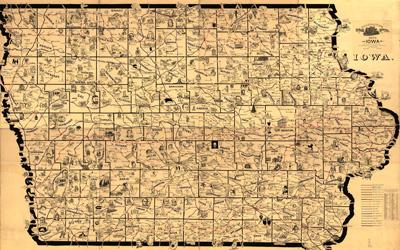
Description
This is a large-scale map of Iowa that shows the routes and post offices of the Railway Mail Service. This map was designed by Chicago railway mail clerk Frank H. Galbraith to help employees of the Railway Mail Service quickly locate counties and post offices.…
Dissected Map of the United States, 1900
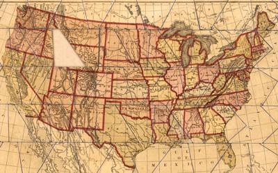
Description
This is a jigsaw puzzle of the United States that is referred to as a dissected map. It was created by the McLoughlin Brothers from New York. It shows all of the 48 contiguous states. One piece appears to be missing in the puzzle.
Standard Map of the World, 1942
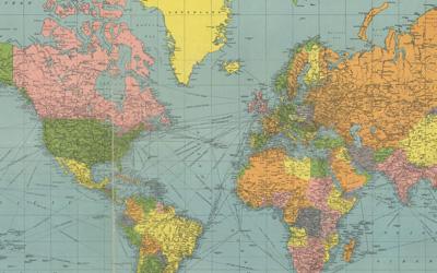
Description
This is a map of the world that was printed in 1942 by Geographia Map Company from New York. This is a Mercator Projection, the map is in color and it shows lines of latitude and longitude. It is laid out in a grid system with North and South America at the center of…
Merchants of the Sahara Desert in North Africa, between 1880 and 1923
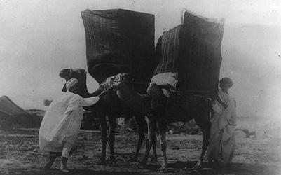
Source Description
The photograph shows two merchants in the Sahara Desert with very large wares on the backs of camels. They are traveling merchants through the desert. The image shows how different places in the world have different types of climate and landscapes than Iowa.
Workers Cutting Bananas from Trees in Costa Rica, between 1910 and 1920
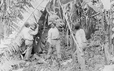
Description
The photograph shows laborers working to cut bananas from trees in Costa Rica. The photo comes from the Frances Carpenter Collection and was taken sometime between 1910 and 1920. This image shows how different places in the world have different types of vegetation and…
Farm Land in Monona, Iowa, May 1940
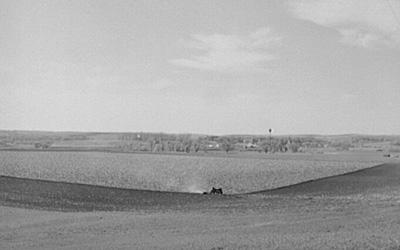
Description
This photo from 1940 shows the landscape of Monona, Iowa, which is located on the western side of the state. This image shows farm land and the area is generally flat and wide open. There are some trees in the background, but mostly it is plowed farm land. …
Gowers' Land Agency, 1855
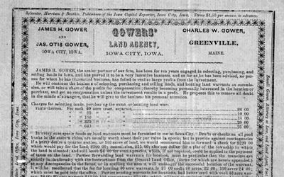
Description
This advertisement was created in 1855 by the Gowers' Land Agency to sell Iowa land, presumably for farming.
"Beautiful Prairies of Early Iowa" Newspaper Article, August 30, 1911
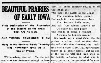
Description
This article was published in The Denison Review and describes the beauty of the Iowa prairie. In the 1911 article, the author quotes poetry, describes the beauty of the wildflowers in Iowa, discusses fires and reveals that the prairie is gone because of…
Freshly Plowed Land in Greene County, Iowa, April 1940
Description
The image was taken in Greene County, Iowa, by photographer John Vachon in 1940. It shows a line down a field where one side is freshly plowed and the other is not. There is a train going by in the background.
Bird's-Eye View of Iowa City in Johnson County, Iowa, 1868
Description
This is a hand-drawn, bird’s-eye view of Iowa City, Iowa, located in Johnson County. The illustration is from 1868 and shows the city next to the Iowa River. The town is laid out in a grid pattern, and the image shows that there is not a lot of trees and the area is…
Railroad Map of Iowa, 1881
Description
The map shows the many railroads running through the state of Iowa in 1881. It was published by the Western Litho Company, but was created by the Iowa Board of Railroad Commissioners, which served as an independent regulatory railroad agency.
Highway next to Farm Land in Grundy County, Iowa, April 1940
Description
This photo captures a car driving through Grundy County, Iowa, in 1940. The image shows a farm in the background and the road is passing through fertile farm land.
Railroad Map of the American Midwest, 1858
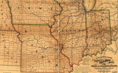
Description
This is a railroad map of the American Midwest. The map shows Indiana, Illinois, Missouri and Iowa.
"National Parks of the Midwest," 1968
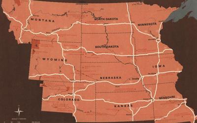
Description
The "National Parks of the Midwest" article and map was created by the National Park Service to highlight different regions of the country, and to encourage travel to those regions. The document includes a description and brief history of the region, as well as a map with…
"Opening of the Midwest" Mural in Cedar Rapids, Iowa, 2011
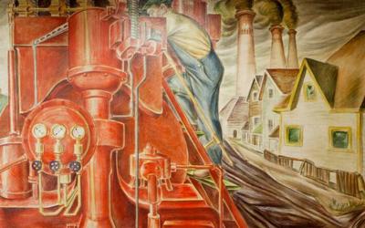
Description
This mural is located at the courthouse in Cedar Rapids, Iowa. It depicts the Midwest region's major industries as Americans moved West. The image shows men working on the railroads, turning prairie land into farms and the rise of factories in the region. The mural was…
Iowa Core Social Studies Standards (6th Grade)
Listed below are the Iowa Core Social Studies content anchor standards that are best reflected in this source set. The content standards applied to this set are middle school-age level and encompass the key disciplines that make up social studies for sixth-grade students.
| No. | Standard Description |
| SS.6.16. | Utilize and construct geographic representations to explain and analyze regional, environmental, and cultural characteristics. |
| SS.6.17. | Analyze and explain the cultural, physical, and environmental characteristics of places and regions and how this affects the life of the people who live there. |
| SS.6.18. | Explain how changes in transportation, communication, and technology influence the movement of people, goods, and ideas in various countries. |
| SS.6.19. | Explain how global changes in population distribution patterns affect changes in land use in particular countries or regions. |