Image

Description
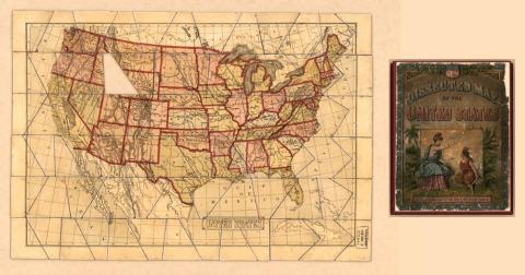
This is a jigsaw puzzle of the United States that is referred to as a dissected map. It was created by the McLoughlin Brothers from New York. It shows all of the 48 contiguous states. One piece appears to be missing in the puzzle.
Source-Dependent Questions
- Which Iowa cities are shown on the map?
- What two lines of latitude and two lines of longitude does the city of Des Moines fall between?
- What states border Iowa?
- Which river forms most of Iowa's western border? Which river forms Iowa's eastern border?
- Looking at the map, what makes Iowa's geographic location similar to and different from other states?
- Compare this map to a current map. Compare the locations of of Des Moines, Iowa City, Sioux City and Dubuque. Is this map accurate? Why or why not?
Citation Information
"Dissected Map of the United States," McLoughlin Bros., Inc., 1900. Courtesy of Library of Congress