Image

Description
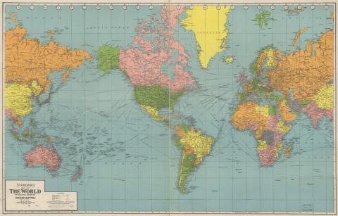
This is a map of the world that was printed in 1942 by Geographia Map Company from New York. This is a Mercator Projection, the map is in color and it shows lines of latitude and longitude. It is laid out in a grid system with North and South America at the center of the map.
Source-Dependent Questions
- Using the grid coordinates at the top and side of the map, what coordinates would all of Iowa be in?
- What grid coordinates would Bombay, India, be in?
- How many hours ahead of Iowa is the city of Cairo, Egypt?
- How many hours behind Iowa is Honolulu, Hawaii?
- Describe where Iowa is in relation to Brazil.
Citation Information
"Standard Map of the World," Geographia Map Company, 1942. Courtesy of Library of Congress