How do humans change their environment?
The current Iowa landscape owes much to the most recent Ice Age and the glaciers that edged down from the north. As the climate grew colder, ice and snow did not melt off over southern Canada but piled up and pushed out the outer edges of huge ice sheets in the form of glaciers. One account describes it as similar to a pancake on the griddle spreading out as batter pours into the center. Several glaciers covered all or portions of Iowa. Northeastern Iowa is called the driftless area because it received little or no glaciation.
From "Great Desert" to Fertile Oasis
At the end of the most recent ice age, the climate was unsteady with periods of warming and cooling. When the unstable climate turned cold and then warmed, glaciers scraped across north central Iowa and then retreated, back and forth, creating flat surfaces and pulverizing rocks and gravel into fine particles. When the climate finally began warming up and drying out, evergreen forests appeared first, then hardwoods, and finally the grasslands the came to characterize the region as we know it. Season after season, the grasses and other prairie plants grew and died, leaving their roots in the soil to create the incredible topsoil for which Iowa is famous. The glaciers left western and southern portions of the state more hilly.
When American explorers began to investigate the newly-purchased Louisiana Territory, Iowa was considered a "great desert." The fertility of the land was measured by its ability to grow trees, and the prairies looked like miles and miles of barren acres. It was not until early families began moving out onto the prairies and, with John Deere's steel plow, scoured off the sticky prairie dirt, discovering the incredible fertility of the deep, black topsoil.
At the beginning of European settlement, Iowa was around 85 percent prairies, treeless grasslands. Trees grew in the hills of southeast Iowa and along major rivers, but on the uplands back from the waterways, fires burned off trees and other woody plants. Early settlers tried to include at least some timber land in their purchases for the fuel, fencing and lumber they needed. Lumber mills along the Mississippi and inland rivers created Iowa’s first millionaires as the flood of settlers that the railroads brought with them built homes, barns and outbuildings and businesses. The coming of the railroads took more trees to make railroad ties. Today, less than 0.1 percent of Iowa's original prairies are left; the rest of the land has been plowed or in some other way altered.
Different Uses for Iowa's Land
Not all Iowa farmland is used in the same way. In the hills of northeast Iowa, dairy farming has deep roots as farmers harvest hay through the summer to feed their herds through the winter. The hillsides are too steep to plow but abundant rainfall produces excellent pasture. Hilly land in southern and western Iowa support livestock production. Many farmers raise herds that produce calves in the spring that graze to a certain weight and then are shipped north to feedlots where they are finished on corn. The flat, fertile fields of north central Iowa are some of the world's most valuable farming acres. Corn and soybeans dominate the landscape, often to the exclusion of trees, shrubs and wildlife habitat that once supported a variety of birds and wildlife. With larger and larger equipment, a single farm operation can now manage thousands of acres, reducing the number of farms, farm families and the small towns that once supported them.
Farming practices have greatly affected the land. In early Iowa, swamps and wetlands accumulated water in rainy seasons making farming impossible. Tiling ponds to drain the water from ponds and wet lands opened thousands of acres to the plow but created the potential for flooding as excess water flowed into streams and rivers very quickly. The use of commercial fertilizers created ecological challenges in the lower Mississippi as chemicals that kill of vegetation and fish accumulate. Deep plowing and rapid run-off also encourages erosion and the loss of Iowa's most precious resource, its rich topsoil. Livestock confinement operations can concentrate animal wastes that can pollute steams or the air. Efforts are now being explored that try to minimize the impacts of these challenges while still allowing the farm production vital to the state’s economy and the world's food and fuel supplies.
Supporting Questions
How has land been changed to grow food?
- "Millions of Acres" Advertisement, 1872 (Image)
- Letter from Giles S. Thomas to His Family, January 3, 1876 (Document)
- "A Modern Iowa Farm," 1927 (Image)
- Farmer Plowing Sod in Grundy County, Iowa, 1940 (Image)
- Plowed Sod in Grundy County, Iowa, 1940 (Image)
How has land been changed to provide energy?
- View of Top of Nevada Power Plant at Hoover Dam, Date Unknown (Image)
- "British Reported Set To Build World's First Nuclear Power Station" Newspaper Article, August 8, 1951 (Document)
- Farm in Hardin County, Iowa, August 18, 2008 (Image)
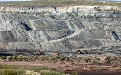
- View of Eagle Butte Coal Mine in Gillette, Wyoming, August 20, 2008 (Image)
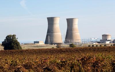
- Nuclear Power Plant in Northern California, 2012 (Image)
How has the environment been impacted by human land use?
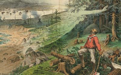
- "Preserve Your Forests from Destruction" Illustration, January 9, 1884 (Image)
- "Farm Wells and Pollution" Newspaper Article, February 25, 1916 (Document)
- "Deforestation Means Famine in U.S." Newspaper Article, May 23, 1921 (Document)
- Dubuque "Shacktown" Near the Banks of a Polluted Stream, April 1940 (Image)
- "Results of Deforestation" in San Juan County, Colorado, September 1940 (Image)
| Changes in Land Use Teaching Guide |
| Printable Image and Document Guide |
"Millions of Acres" Advertisement, 1872
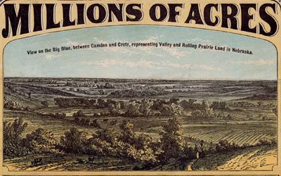
Description
This was an advertisement created by the Burlington & Missouri River Railroad Co. in 1872 to increase land sales in Iowa and Nebraska. This flyer promoted "millions of acres" of land being sold on 10 years credit with six percent interest.
Letter from Giles S. Thomas to His Family, January 3, 1876
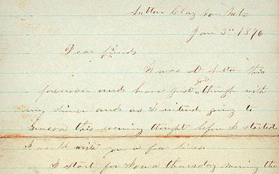
Description
In this letter, Giles S. Thomas discusses traveling across Iowa and the weather. He indicates that the winter was mild, and farmers were able to get into their fields early to begin plowing the land.
"A Modern Iowa Farm," 1927
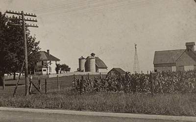
Description
This stereograph shows an Iowa farm from 1927. The image shows the farmland, house, barn and other buildings on the property.
Farmer Plowing Sod in Grundy County, Iowa, 1940
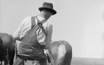
Description
The photo was taken by John Vachon in April 1940, and it shows a farmer in Grundy County, Iowa, plowing a field. The farmer is sitting on the plow, which is being pulled by horses.
Plowed Sod in Grundy County, Iowa, 1940
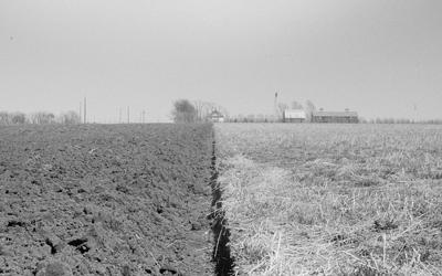
Description
The photograph was taken by John Vachon in April 1940, who also took the photo that shows the Iowa farmer plowing sod. The image shows a field in Grundy County, which is located in northeast Iowa. That field has been half plowed,…
View of Top of Nevada Power Plant at Hoover Dam, Date Unknown
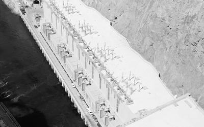
Description
This photograph shows an aerial view of the Hoover Dam with a power station at the top. On one side of the dam, there is visible water, while on the other side, there is none. The Hoover Dam is on the border between Nevada and Arizona. It was constructed between 1931 and…
"British Reported Set To Build World's First Nuclear Power Station" Newspaper Article, August 8, 1951
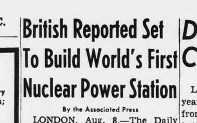
Description
This article was published in the Washington, D.C., newspaper, The Evening Star. Written by the Associated Press, it reads that British atomic scientists have announced they are ready to begin building the world's first nuclear power station. This article was…
Farm in Hardin County, Iowa, August 18, 2008
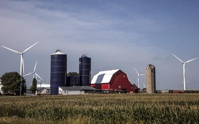
Description
This 2008 photography shows an Iowa farm with two tall blue silos, sheds, a house and a blue sky in the background. There is a cornfield in the foreground and large, white wind turbines in the background. Iowa is a national leader in wind energy, producing the…
View of Eagle Butte Coal Mine in Gillette, Wyoming, August 20, 2008
Description
The photograph shows an open-pit "truck and shovel" mine in Gillette, Wyoming. Called the Eagle Butte coal mine, it produces low-sulfur, sub-bituminous coal from the vast Roland and Smith seams. This coal is used for domestic energy generation.
Nuclear Power Plant in Northern California, 2012
Description
This 2012 photograph taken by Carol Highsmith shows a nuclear power plant in a field in northern California. As of late 2016, there are 60 commercially-operating nuclear power plants with 98 nuclear reactors in the United States. But the state of California has been…
"Preserve Your Forests from Destruction" Illustration, January 9, 1884
Description
This illustration shows a female spirit labeled "Public Spirit" warning two men cutting logs of the consequences of deforestation. The bottom of the image reads, "Preserve your forests from destruction, and protect your country from floods and drought."
"Farm Wells and Pollution" Newspaper Article, February 25, 1916
Description
The article was published by the United States Department of Agriculture and addresses how clean water practices are an important part of farming. Published February 25, 1916, the article states that farmers need to consider the quality of their water, and that polluted…
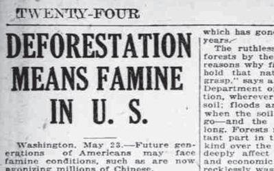
"Deforestation Means Famine in U.S." Newspaper Article, May 23, 1921
Description
This newspaper article was published in 1921, and it discusses the negative, long-term effects of deforestation. The article suggests that Americans could face a famine, similar to what was happening in China at the time, because of the amount of deforestation that was…
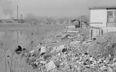
Dubuque "Shacktown" Near the Banks of a Polluted Stream, April 1940
Description
This photography shows a "Shacktown" near Dubuque, located in northeast Iowa. The dilapidated "Shacktown" is located near the banks of a polluted stream. The image was captured in April 1940.
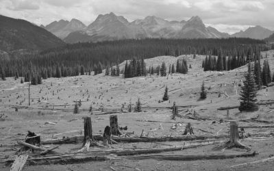
"Results of Deforestation" in San Juan County, Colorado, September 1940
Description
The photograph was taken in September 1940 in San Juan County, Colorado. The photo shows the results of deforestation for mining purposes in Colorado. Many trees can be seen cut down, which drastically changed the landscape and forest.
Additional Resource
-
"Energy Sprawl is the Largest Driver of Land Use Change in the U.S." by Cara Cannon Byington
This online blog from "Cool Green Science" website focuses on how the diversity of the energy industry - or sprawl - has had one of the biggest impacts to land use in the United States.
Iowa Core Social Studies Standards (6th Grade)
Listed below are the Iowa Core Social Studies content anchor standards that are best reflected in this source set. The content standards applied to this set are middle school-age level and encompass the key disciplines that make up social studies for sixth-grade students.
| No. | Standard Description |
| SS.6.18. | Explain how changes in transportation, communication, and technology influence the movement of people, goods, and ideas in various countries. |
| SS.6.19. | Explain how changes in population distribution patterns affect changes in land use in particular countries or regions. |