What factors, forces or reasons cause people to move from one geographic area to another?
The first people to live in what we now call Iowa may have arrived some 8,000-10,000 years ago. They lived along the edges of the receding glaciers and hunted large game animals. Gradually, groups began to plant and harvest gardens of corn, beans, pumpkins and squash and gather nuts, berries and fruits to supplement their meat supply. By around 1,200 C.E., corn had migrated along the Gulf Coast and up the Mississippi to tribes in the Upper Midwest who became known as the Oneota culture. They established villages to which they returned for many years after seasonal deer and buffalo hunts.
European Arrival
The arrival of Europeans on the continent had an impact on the Midwest long before permanent settlers came. French and English colonies along the Atlantic Coast displaced eastern American Indian tribes who were forced west to compete with existing tribes. The earliest French and English these tribes encountered were not settlers competing for lands fur trappers and traders. They brought with them manufactured goods — blankets, cookware, knives, guns — to exchange for beaver, deer and other skins that sold for high prices in Europe.
Internal competition among both American Indians and European sides of the trading partnership led to conflicts. As the French and English battled for control the Atlantic Coast and Canada, they made allegiances with tribes. The French clashed with the Meskwaki (sometimes mistakenly called the Fox) and their Sac allies who were forced south from their homelands in Wisconsin and Michigan into eastern Iowa. These tribes became allies of the British against the French and later against the former British colonists, the Americans.
The other major tribe as American settlement began to put direct pressure Iowa lands in the 19th C. were the Sioux across the northern regions of future Iowa. The Sioux were the last to relocate out of the state in 1851.
Conflict and Consequences of "Western Expansion"
From the earliest days of European settlement on the Atlantic Coast, pioneers began moving west not just to trade but to live and raise families. This is known as Westward Expansion. Of course, American Indians were already occupying those western lands, setting up conflict situations. In 1832, when the U.S. government tried to enforce the terms of a treaty that demanded removal of the Sac from their major village Saukenuk on the Illinois side of the river. Chief Black Hawk resisted and returned in the spring with a portion of the tribe in defiance of the government order. In the Black Hawk “War” that ensued, U.S. troops and the Illinois state militia quickly routed Indian resistance and forced Sac families to flee. The treaty that followed opened eastern Iowa to American settlement and pushed the Sac and their Meskwaki allies into central Iowa. Treaties between the tribes and the U.S. government eventually provided for relocation of the tribes to western lands and the removal of Indian claim to the land.
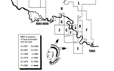
Iowa has no Indian reservations, land owned by the U.S. government but occupied by recognized Indian tribes. In the 1850s, Meskwaki tribal members pooled their government annuity payments and, with the consent of the state government, purchased land in Tama County that became known as the Meskwaki Settlement. The tribe, not the government, owns the land. Many members of the tribe began to return to Iowa where they have lived ever since. The modern Meskwaki Settlement in Tama County maintains tribal schools, courts, and police and a public works department. Their annual powwow attracts thousands every year who watch traditional dances and learn about Meskwaki history and culture. Because they are not subject to state laws, the tribe opened a very successful casino that has brought a new prosperity to the Meskwaki. Sioux City is home to another sizable group of American Indians who sponsor a day care that promotes community activities and services to members of several tribes in the area. American Indians have a significant story in Iowa history and are a vibrant part of the Iowa of today.
Supporting Questions
What was Westward Expansion?
- "American Progress," 1873 (Image)
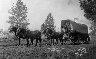
- Typical Immigrant Outfit in Central Oregon, December 5, 1910 (Image)
- Lewis and Clark Expedition Map for Bicentennial Anniversary, 2003 (Map)
Who are American Indians? Who are the Meskwaki?
- Outline Map of Indian Localities of 1833, Date Unknown (Map)
- Dakota Sioux in the Great Plains, 1905 (Image)
- Meskwaki Weaving in Wickiup in Tama, Iowa, 1905 (Image)
- Eskimo Children "Under the Salmon Row," 1906 (Image)
- Hopi Indian Harvest Dance, between 1909 and 1919 (Image)
- Cree Man Calling a Moose, 1927 (Image)
- Seminole Men, Women and Children, 1936 (Image)
- Meskwaki Code Talkers, February 26, 1941 (Image)
- Meskwaki Powwow Celebration in Tama, Iowa, 1953 (Image)
- Timeline of "How the Meskwaki and Sauki Became Three Separate 'Sac & Fox' Tribes," 2004 (Document)
- Meskwaki Land Purchases, 2004 (Document, Map)
- Meskwaki New Settlement School, Date Unknown (Image)
What happens when cultures collide?
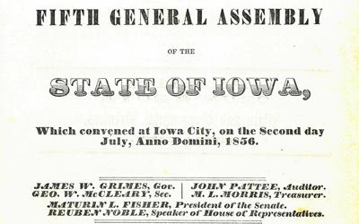
- Iowa Law to "Allow Meskwaki to Purchase Land and Live in Tama, Iowa," July 15, 1856 (Document)
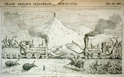
- "Does Not Such a Meeting Make Amends?" May 29, 1869 (Political Cartoon)
- Iowa Public Television's "Iowa Land for Sale," 1977 (Video)
- History of the Meskwaki Timeline, 2004 (Document)
| American Indians and Westward Expansion Source Set Teaching Guide |
| Printable Image and Document Guide |
"American Progress," 1873
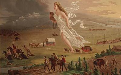
Description
This print, also entitled "Manifest Destiny," shows an allegorical female figure representing "America" that is leading pioneers westward. The settlers are traveling on foot, in a stagecoach, by conestoga wagon and railroads. These pioneers are shown encountering …
Lewis and Clark Expedition Map for Bicentennial Anniversary, 2003
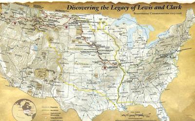
Description
This map commemorates the 200th anniversary of Meriwether Lewis and William Clark's expedition to cross what is now the western portion of the United States of America. This map includes additional features that highlight their journey, such as a legend that features…
Outline Map of Indian Localities of 1833, Date Unknown
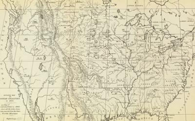
Description
The map shows American Indian tribe locations as of 1833. The map was created by George Catlin, an American painter who specialized in portraits of Native Americans in the Old West.
Meskwaki New Settlement School, Date Unknown

Description
The photograph shows the Meskwaki Settlement School on the Meskwaki Indian settlement. The Sac and Fox Settlement School originally was established as a day school by the Bureau of Indian Affairs. Next, it became part of the South Tama County Community School District…
Meskwaki Code Talkers, February 26, 1941
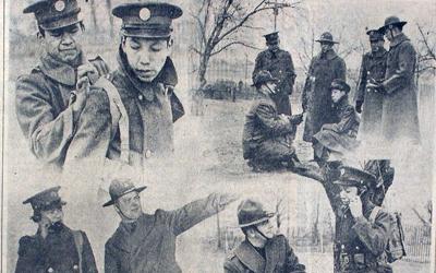
Description
The news clipping shows a composite picture showing how eight Sac and Fox Native American men, all member of Company H in the 186th Infantry, used their Meskwaki language to be "code talkers" during World War II. The photo shows how the communication network of…
Dakota Sioux in the Great Plains, 1905
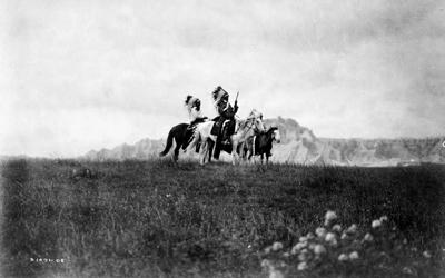
Description
Three Sioux American Indians of horseback are photographed along the Great Plains with a rock formation in background. The image was taken by Edward Curtis in 1906.
Meskwaki Weaving in Wickiup in Tama, Iowa, 1905
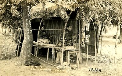
Description
Two women are shown weaving in a Wickiup, which is Native American hut covered with brushwood or grass. The 1905 photograph was taken in Tama, Iowa.
Eskimo Children "Under the Salmon Row," 1906
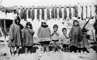
Description
The photograph features Eskimo children posing under salmon hanging from a rack. The image was taken by Frank Nowell in Alaska in 1906.
Hopi Indian Harvest Dance, between 1909 and 1919
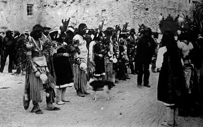
Description
The photograph show Hopi American Indians participating in the Harvest Dance. The image of the Hopi was taken in the southwest. Today, most members of the Hopi tribe reside in northeast Arizona.
Cree Man Calling a Moose, 1927
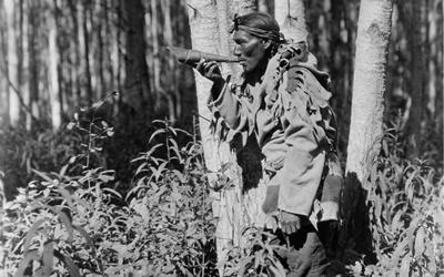
Description
Edward Curtis' photograph shows a man in the woods blowing his horn to attract moose. The American Indian man is a member of the Cree, who were based along the northwest coast. Today, members of the Cree tribe primarily live in Montana and throughout north and west…
Seminole Men, Women and Children, 1936
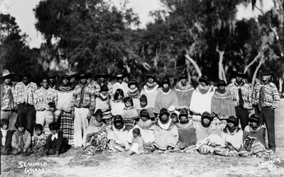
Description
A group of men, women and children, all Seminole American Indians, are posing outdoors. The image was taken in Florida in 1936.
Meskwaki Powwow Celebration in Tama, Iowa, 1953
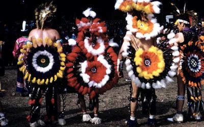
Description
The annual powwow celebration is a time for renewing contacts within and outside the Meskwaki tribe. Costumed dancers, food and souvenir vendors and special programs are offered every August. The photograph shows Meskwaki men in tradition dress participating in the powwow…
Timeline of "How the Meskwaki and Sauki Became Three Separate 'Sac & Fox' Tribes," 2004
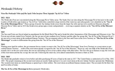
Description
This timeline, compiled by the Meskwaki Nation Historical Preservation Office, shows how the Meskwaki and Sac tribes became three separate "Sac & Fox" tribes between 1812 and 1869.
Meskwaki Land Purchases, 2004
Description
This map and accompanying text show the history of land purchases made by the Meskwaki tribe.
Iowa Law to "Allow Meskwaki to Purchase Land and Live in Tama, Iowa," July 15, 1856
Description
This is an excerpt of the journal from the 5th General Assembly of Iowa in 1856. The journal page shows the law that was enacted so the Meskwaki could purchase land and live in Tama, Iowa.
"Does Not Such a Meeting Make Amends?" May 29, 1869
Description
This print shows an allegory that symbolically shows the linking of the transcontinental railroad at Promontory Summit in Utah. American Indians and buffalo are fleeing in the foreground as two trains with large hands extending from the locomotives, labeled "San…
Typical Immigrant Outfit in Central Oregon, December 5, 1910
Description
The photograph from 1910 shows immigrants in a horse-drawn Conestoga wagon in Central Oregon.
Iowa Public Television's "Iowa Land for Sale," 1977
Description
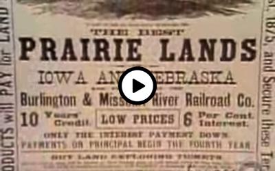
This video from Iowa Public Television describes how settlers purchased their land from the government, speculators and the railroads in the early 1800s. In brief, the government land was first sold for $1.25 an acre to speculators. In the 1850s, over 10 percent of all land…
History of the Meskwaki Timeline, 2004
Description
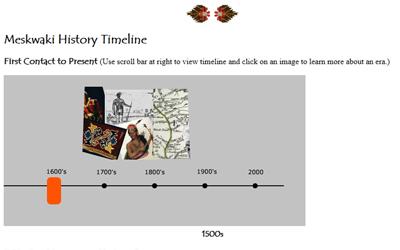
This timeline records the history of the Meskwaki people from the early 1880s to present.
Additional Resources:
- Louisiana Purchase
This two-minute video explains Thomas Jefferson's work to buy - on behalf of the United States - 800,000 square miles from the French, stretching from the Mississippi River to the Rocky Mountains that would be known as the Louisiana Purchase. - Seaman’s Journal: On the Trail With Lewis and Clark by Patricia Eubank
This is a children’s book of Lewis and Clark's expedition told through Lewis’ dog, Seaman's, point of view. - Trail of Tears Article from the Library of Congress
"Trail of Tears Powwow; A Local Legacy" article summarizes the forced migration of the Trail of Tears. It also describes a commemorative park and highlights a powwow celebration. - Daniel Freeman’s Homestead Certificate
This website features a homesteading certificate of eligibility for Daniel Freeman from January 20, 1868. The Homestead Act of 1862 made 160 acres available to any head of household who filed a claim, lived five years on the land and paid a fee. - "The Long Way Home" Article from the Goldfinch: Iowa History for Young People
This article focuses on the life of a young Meskwaki woman. The Goldfinch was published quarterly by the State Historical Society of Iowa from 1975-2000. - "Removing Native Americans from their Land" from the Library of Congress
This webpage focuses on the removal of American Indians from their lands at the bequest and action of the U.S. government and President Andrew Jackson. - Sac And Fox Native American Fact Sheet
The website was written for young people to learn about the Fox and Sacs tribes for schoolchildren. - Building the Transcontinental Railroad by Joeming Dunn
This graphic novel follows the transcontinental railroad's progress with maps, timelines and glossaries to guide classroom discussion. - The Oregon Trail by Joeming Dunn
This graphic novel follows the expedition of the Oregon trail for the pioneers that made the trip. It features maps, timelines and glossaries to guide classroom discussion.
Iowa Core Social Studies Standards (3rd Grade)
Listed below are the Iowa Core Social Studies content anchor standards that are best reflected in this source set. The content standards applied to this set are elementary-age level and encompass the key disciplines that make up social studies for third grade students.
| No. | Standard Description |
| SS.3.11. | Provide examples of historical and contemporary ways that societies have changed. |
| SS.3.13. | Identify how people use natural resources, human resources, and physical capital to produce goods and services. |
| SS.3.18. | Determine the importance of saving/investing in relation to future needs. |
| SS.3.19. | Create a geographic representation to explain how the unique characteristics of a place affect migration |
| SS.3.21. | Use map evidence to explain how human settlements and movements relate to the locations and use of various regional landforms and natural resources. |
| SS.3.25. | Explain probable causes and effects of events and developments. |
| SS.3.26. | Develop a claim about the past based on cited evidence. |
| SS.3.27. | Analyze the movement of different groups in and out of Iowa including the removal and return of Indigenous people. |