Image

Description
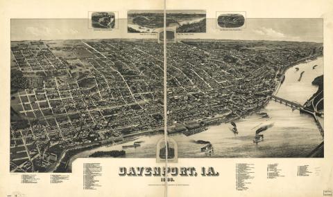
This map is a bird's-eye view map of Davenport, Iowa. While this map primarily shows the major buildings and streets of Davenport, Iowa, it also shows major landforms and how the streets layout had to be adjusted around them. The population of Davenport was 26,872 in 1890 and had grown to 99,685 in 2010.
Source-Dependent Questions
- Is Davenport, Iowa, an urban area or a rural area? Use evidence from the map to support your answer.
- Compare and contrast this map to the map of Chicago, Illinois, in 1857. How are the roads and buildings the same, and how are they different?
- How do the landforms affect the layout of the streets in Davenport? For example, look for the tallest tree-covered hills and see how the street layout pattern changes.
Citation Information
Wellge, H., "Davenport, Ia.," 1888. Courtesy of Library of Congress