Image

Description
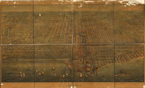
A bird’s eye view, this is a panoramic map of Chicago, Illinois. Even though this perspective map is not drawn to scale, it shows the buildings, streets and general layout of downtown Chicago as of 1857. The population of Chicago was 112,172 in 1860 and was 2,695,598 in 2010.
Source-Dependent Questions
- Is Chicago, Illinois, an urban area or a rural area? Use evidence from the map to support your answer.
- Compare and contrast this map to that of Davenport, Iowa, in 1888. How are the roads and buildings the same, and how are they different?
Citation Information
Palmatary, J.T., Christian Inger, Herline & Hensel and Braunhold & Sonne, "Chicago," 1857. Courtesy of Library of Congress