Image

Description
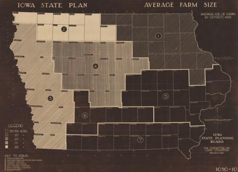
In 1933, the State Planning Board of Iowa, a special committee that only existed from 1934 to 1939 to study long-term land use plans for the state, published this map showing the average farm size measured in number of acres. They also showed if the land was used for cash grain cops and/or livestock.
Transcript of Average Farm Size in Iowa Map
Source-Dependent Questions
- Which district has the largest average farm size In Iowa? Explain how you know which district that is.
- Look at the map, "Number of Farms and Average Farm Size, Iowa: 1950-2014." How did the size of Iowa farms change from 1932 to 1950?
Citation Information
"Average farm size: average size of farms by district, 1932," Iowa State Planning Board, 1933. Courtesy of University of Iowa Library and Archives