Image

Description
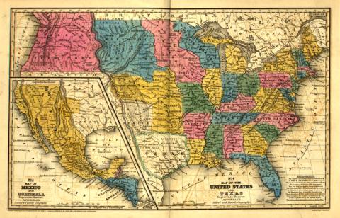
This map appeared in Mitchell’s School Atlas in 1839. It shows the territories formed from the Louisiana Territory Purchase as well as several states that had already been carved from Louisiana Territory. The Iowa territory is shown in pink.
Source-Dependent Questions
- Compare and contrast this 1839 map with a current U.S. map. What is the same? What is different? What observations can you make about the border of Iowa territory compared to the border of the modern state?
- Refer back to the Act of Congress to Admit Iowa and Florida into the Union, March 3, 1845. Why would a conflict about Iowa’s southern border relate to the issue of slavery?
Citation Information
Mitchell, S. Augustus, Young, J.H., & Cowperthwait & Co Thomas, "Mitchell's School Atlas," 1839. Courtesy of Library of Congress