Image

Description
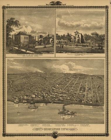
The bottom two-thirds of the page provide a perspective map of the city of Muscatine, which was located on the Mississippi River and was one of the important river towns from Iowa's early history. This perspective map depicts the city in 1875 and was included in an atlas of the entire state of Iowa. The cost of publishing the atlas was underwritten through the sale of subscriptions. Those individuals who purchased a subscription had the location of their residences included on the township maps in the atlas.
Transcript of the "Illustrated Historical Atlas of the State of Iowa"
Source-Dependent Questions
- The view of Muscatine was from the Mississippi River looking west across the city. What geographic features influenced the development of Muscatine? Use details from the lithograph to explain your reasoning.
- Compare this image of Muscatine with the lithograph of Council Bluffs. Do the stories of settlement told by these images support or refute the descriptions of The Iowa Patriot and Jeff Thompson? Explain your reasoning.
Citation Information
Andreas, Alfred T., "Illustrated Historical Atlas of the State of Iowa," 1875. Courtesy of Library of Congress