Image

Description
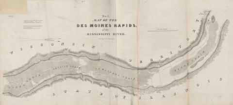
This map was part of a collection of maps, drawings and surveys of North America, the United States and the world in 1843. Everything in the collection was created on the orders of the U.S. Congress.
Source-Dependent Questions
- What was the primary reason for creating this map? Identify evidence from the source to support your answer.
- According to the labels and the key, when had Congress become interested in the Des Moines Rapids?
Citation Information
"No.1 Map of the Des Moines Rapids of the Mississippi River," Collection of Maps, Charts, Drawings, Surveys, Etc., Published from Time to Time, By Order of the Two Houses of Congress, pp. 187, 1843. Courtesy of Library of Congress