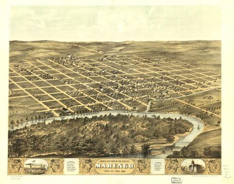
Description
This is a bird's-eye view map of Marengo, Iowa, which was created in 1868 by the Merchant's Lithographing Company of Chicago. The bottom of the map in the middle reads, "Bird's Eye View of the City of Marengo Iowa Co. Iowa 1868." The references to the left read: 1. Court House, 2. County Jail, 3. Public School, 4. C.R.I. & P.R.R. Depot, 5. Fair Ground. The churches box on the right read: 6. Presbyterian, 7. Christian, 8. Methodist, 9. Catholic. This map is part of a collection of more than 1,700 such maps at the Library of Congress. The panoramic map was a popular cartographic form used to depict U.S. and Canadian cities and towns during the late nineteenth and early twentieth centuries. In 1870, 1,693 people lived in Marengo.
Source-Dependent Questions
- Is Marengo, Iowa, an urban area or a rural area? Use evidence from the map to support your answer.
- Look at how the land is used in Marengo. What patterns do you see in the number of streets and roads, spacing of the houses, location of businesses, etc., that can help you decide if this is an urban area or a rural area?
Citation Information
Ruger, A., "Bird's eye view of the city of Marengo, Iowa Co., Iowa," 1868. Courtesy of Library of Congress