Image

Description
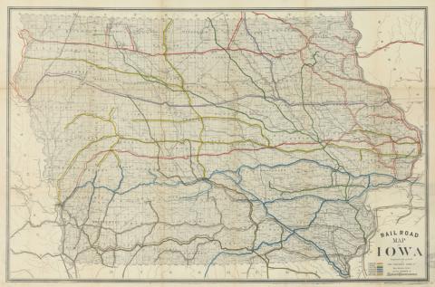
This 1881 map of Iowa shows the railroads that criss-crossed Iowa. Townships and counties are also shown on the map. The railroad tracks are color-coded to show the numerous rail companies that were operating in Iowa in 1881.
Transcript of 1881 Railroad Map of Iowa
Source-Dependent Question
- Look closely at the map, each railroad company is represented by a different color. How many railroad companies were operating in Iowa in 1881? What railroad company had the most lines in Iowa?
- Locate where you live in Iowa. Do the railways that serviced your community in 1881 still exist? Use this map of current rail lines to help you answer the question. Study the 1881 map and develop a theory as to why the rail lines in your area are either still being used or have been abandoned.
- Compare this map with the 1856 map. What do you observe about the number of railways in Iowa? Investigate historical events between 1856 and 1881 and propose two or three reasons why the number of railways in Iowa changed over that time period.
Citation Information
"Railroad map of Iowa, 1881," Iowa Board of Railroad Commissioners, Western Litho Co., 1881. Courtesy of University of Iowa Libraries and Archives